Category Archives: News

December 31, 2018

Warm and Breezy Start to the New Year

Expect warm and occasionally windy conditions with passing showers on 3 – 4 days as we step into the first week of the new year. Warm and windy weather likely to ease with more showers expected towards the end of the 1st week of Jan 2019.

Singapore, 31 December 2018 – The prevailing Northeast Monsoon in the region is expected to persist into January 2019 with the high pressure system over the northern Asian continent strengthening over the next few days. The low level winds are forecast to blow mainly from the northwest in the first week before shifting to blow from the northeast towards the second week of January 2019.

2         In the first fortnight of January 2019, Singapore is expected to experience short-duration moderate to heavy thundery showers mainly in the afternoon on six to eight days. In the first week of the month, a tropical storm is forecast to move into the South China Sea and bring a strengthening of northwesterly to northerly winds over Singapore and the surrounding region. Coupled with slightly drier atmospheric conditions, warm and occasionally windy conditions with passing showers can be expected on three to four days that week.

3         The daily temperatures in the first fortnight of January 2019 are expected to range between 24°C and 33°C on most days. On days when there is little or no rainfall, warm conditions with maximum temperatures of around 34°C can be expected.

4         The warm and windy weather is likely to ease with more showers expected towards the end of the first week of January 2019. Overall, rainfall for the first fortnight of January 2019 is forecast to be near-normal.

5          For updates of the daily weather forecast, please visit our MSS website (https://www.weather.gov.sg), NEA website (www.nea.gov.sg), or download the myENV app, or the MSS’ Weather@SG app.

REVIEW (1 – 30 December 2018)

6          Northeast Monsoon conditions prevailed in December 2018, with low level winds blowing mainly from the north or northeast in the first three weeks of the month. Under the influence of a low pressure system in the South China Sea in the last week of December 2018, the low level winds over Singapore and the surrounding vicinity turned to blow from the west.

7         Singapore and the surrounding region experienced wet weather conditions in the first three weeks of the month due to the close proximity of the monsoon rain band to the equatorial South China Sea region. Thundery showers fell over many parts of the island in the afternoon on most days during this period, occasionally stretching into the evening. The highest daily total rainfall of 97.3 mm was recorded on 20 December 2018 at Yio Chu Kang. The intense thunderstorms, which developed due to strong solar heating, brought gusty winds that felled two trees at Sembawang Park. A maximum wind gust of 63.0 km/h was recorded at Seletar on that day. In addition, a waterspout developed from intense thunderstorms over the sea areas southeast of East Coast Park, which was sighted from various locations in Singapore in the late afternoon.

8        The last week of December 2018 saw a change in winds to blow more from the west and showers affected mainly the western and southern parts of Singapore on a few mornings. A Sumatra squall affected Singapore in the early hours and predawn hours on 26 December 2018, bringing thundery showers and gusty winds to parts of the island. The strongest wind gust of 77.4 km/h was recorded at Pasir Panjang on that day. In the last week of 2018, Singapore experienced drier and warmer conditions due to strong solar heating and low rainfall under the stable atmospheric conditions over our region, arising from a low pressure system in the South China Sea that drew some rainclouds away from our region.

9          During the month, Singapore’s daily maximum temperature ranged between 32.5°C and 34.0°C.  The highest daily maximum temperature of 34.7°C was recorded on 23 December 2018 in the Newton area. The daily minimum temperature mainly ranged between 23.0°C and 24.5°C. At the Changi climate station, the mean monthly temperature for December 2018 (as of 30 December) is 27.6°C. This is 1.2°C higher than the long term average temperature of 26.4 deg C for December, and slightly warmer than the December in the last two years.

10         About two thirds of the island received below normal rainfall in December 2018. The lowest rainfall of 126.2mm (58% below average) was recorded in the Pasir Ris area. Rainfall was highest around the Jurong area where 357.4mm (33% above average) was recorded.


CLIMATE STATION STATISTICS FOR DECEMBER (Climatological reference period: 1981 – 2010)

Mean daily maximum temperature 30.2 °C
Mean daily minimum temperature 24.0 °C
Mean monthly temperature 26.4 °C
Mean rainfall for the month 318.6 mm
Mean number of rain days 18
Highest monthly mean daily maximum temperature 31.3 °C (1997, 2002)
Lowest monthly mean daily minimum temperature 23.0 °C (1981,1983)
Highest monthly rainfall 765.9 mm (2006)
Lowest monthly rainfall 62.9 mm (1988)

December 14, 2018

Expect More Thundery Showers For The Rest of December 2018

Expect 6-8 days of afternoon thundery showers in the next fortnight. A monsoon surge towards last week of the fortnight likely to bring 1-2 days of more intense thunderstorm activities and occasionally windy conditions. The daily temperatures between 24°C and 33°C on most days.

Singapore, 14 December 2018 –  The prevailing Northeast Monsoon in the region is expected to persist in the next few months, with the low level winds blowing mostly from the northeast or northwest.

2          In the next fortnight, Singapore can expect short-duration thundery showers in the afternoon and evening on six to eight days.  In addition, towards the last week of December 2018, a surge of monsoon winds over the South China Sea is likely to bring converging winds over the region and more intense thunderstorm activities over Singapore on one to two days, accompanied by occasionally windy conditions.   On another one or two days of the fortnight, the prevailing winds are forecast to temporarily blow from the west, bringing thundery showers in the morning.  The rainfall for December 2018 is expected to be near normal.

3          The daily temperatures in the second fortnight of December 2018 are expected to range between 24°C and 33°C on most days. The daily maximum temperature may reach a high of 34°C on a few days, with the minimum temperature dropping to a low of 23°C on days with intense rainfall.

4          For updates of the daily weather forecast, please visit our MSS website (https://www.weather.gov.sg), NEA website (www.nea.gov.sg), or download the myENV app, or the MSS’ Weather@SG app.

REVIEW (1 – 13 December 2018)

5          Following the onset of the Northeast Monsoon in late November 2018, Singapore and the surrounding region experienced wet weather conditions in the first fortnight of December 2018 as monsoon rain band developed close to the equatorial South China Sea.  Thundery showers fell over many parts of the island in the afternoon on most days during the period. The highest daily total rainfall of 73.4 mm was recorded on 5 December 2018 over the western parts of Singapore near Lim Chu Kang in the late afternoon.

6          Towards the end of the fortnight, a large-scale convergence of northeasterly winds triggered by a moderate monsoon surge over the South China Sea led to the development of intense thundery showers in the afternoon on 11 December 2018.The highest daily total rainfall was recorded at Pulau Ubin  (73.2 mm) and Thomson Road (72.6 mm) on 11 and 12 December 2018 respectively. Floods were reported over several places near Dunearn Road and Eng Neo Road following the heavy downpour on 12 December 2018.

7          During the fortnight, Singapore’s daily maximum temperature ranged between 32.0°C and 33.7°C on most days.  The highest daily maximum temperature of 34.6°C was recorded on 9 December 2018 in the Marina Bay area. The daily minimum temperature ranged between 23.0°C and 24.5°C

8          More than two thirds of the island received above normal rainfall in the first fortnight of December 2018. The highest rainfall of 262.6 mm was recorded in the Jurong Pier area while Changi recorded the lowest rainfall of 52 mm.

FortnightRain_Anomaly_201812aa


CLIMATE STATION STATISTICS FOR DECEMBER (Climatological reference period: 1981 – 2010)

Mean daily maximum temperature 30.2 °C
Mean daily minimum temperature 24.0 °C
Mean monthly temperature 26.4 °C
Mean rainfall for the month 318.6 mm
Mean number of rain days 18
Highest monthly mean daily maximum temperature 31.3 °C (1997, 2002)
Lowest monthly mean daily minimum temperature 23.0 °C (1981,1983)
Highest monthly rainfall 765.9 mm (2006)
Lowest monthly rainfall 62.9 mm (1988)

November 30, 2018

Onset of Northeast Monsoon to Bring More Wet Weather

Northeast Monsoon conditions with prevailing northeast winds have set in over S’pore. In next fortnight, expect 7-9 days of afternoon thundery showers, and 1-2 days to be cloudy and occasionally windy with widespread rain due to monsoon surge.

Singapore, 30 November 2018 – The Northeast Monsoon season has set in over Singapore and the surrounding region, and is expected to prevail till March 2019. During the season, the prevailing winds over the region are expected to blow mainly from the northeast or northwest.

2         For the next two months, the Northeast Monsoon will be in its wet phase where the monsoon rain band typically lies over the equatorial South China Sea. Over Singapore and the surrounding region, it is likely to be wet with more occurrences of short-duration moderate to heavy thundery showers in the afternoon. On some days during the season, a surge of strong northeasterly winds blowing southward over the South China Sea could bring occasionally windy conditions with frequent spells of widespread rain showers over Singapore and the surrounding vicinity. This strengthening of northeasterly winds over the South China Sea, known as a monsoon surge, can last for between two and five days, and also bring cooler temperatures to Singapore. Between two and four monsoon surge events can be expected during the wet phase of the Northeast Monsoon season.

3         The weather in the first fortnight of December 2018 is expected be wet. On seven to nine days in the fortnight, thundery showers occurring mostly in the afternoon can be expected. On a few of these days, the showers could extend into the evening. A monsoon surge is forecast towards the end of the fortnight. This could bring cloudy and occasionally windy conditions with periods of moderate rain, heavy at times, over Singapore and the surrounding region for one or two days. The prevailing winds are also expected to shift to temporarily blow from the west on one to two days during the fortnight. This could bring thundery showers over the island in the morning from a Sumatra squall. For the first half of December 2018, rainfall is forecast to be above normal.

4         In the first half of December 2018, the daily temperature on most days is expected to range between 24°C and 32°C.  There could be a few days during the period where cooler temperatures are expected and the daily minimum temperature recorded could reach a low of between 22°C and 23°C.

5          For updates of the daily weather forecast, please visit our MSS website (https://www.weather.gov.sg), NEA website (www.nea.gov.sg), or download the myENV app, or the MSS’ Weather@SG app.

REVIEW (1 – 29 November 2018)

6         Singapore experienced relatively wet conditions in November 2018. Thundery showers fell over the island on most days of the month.

7         The prevailing winds in November 2018 were mostly light and variable in direction until the end of the month where there was a change in the winds to blow more from the northeast. This change in wind direction in the last week of November 2018 signalled the cessation of the inter-monsoon period and the start of the Northeast Monsoon season.

8       In the first half of November 2018, the light wind conditions coupled with strong solar heating of land areas were conducive for the development of thunderstorm clouds. This brought intense thundery showers in the afternoon over Singapore. In the second half of the month, the prevailing winds blew from the southwest or west for several days, feeding into a low pressure system north of Singapore in the South China Sea. On several days, the thundery showers over Singapore between the early hours and morning were due to Sumatra squalls moving from the Strait of Malacca over the island.

9       The highest daily total rainfall recorded in November 2018 was 110.8mm at Tuas on 21 November 2018. The heavy rainfall that day was caused by an intense Sumatra squall that brought widespread thundery showers accompanied gusty winds over the island. The strongest gust recorded that day was 73.8 km/h at Pasir Panjang. The second highest daily total rainfall of 104.5mm was recorded at Holland Road on 11 November 2018.

10       In November 2018, the daily maximum temperature on most days ranged between 32°C and 34°C. The highest daily maximum temperature recorded was 34.8°C on 28 November 2018 at Clementi. The daily minimum temperature on most days ranged between 23°C and 24°C, and the lowest minimum temperature recorded in the month was 21.4°C on 17 November 2018 at Jurong West.

11       Many parts of Singapore received well above average rainfall in November 2018. The highest rainfall of 433.8 mm (80% above average) was recorded at Jurong, and the lowest rainfall of 162 mm (35% below the average) was recorded at Changi.

20181030rainfall

CLIMATE STATION STATISTICS FOR DECEMBER (Climatological reference period: 1981 – 2010)

Mean daily maximum temperature 30.2 °C
Mean daily minimum temperature 24.0 °C
Mean monthly temperature 26.4 °C
Mean rainfall for the month 318.6 mm
Mean number of rain days 18
Highest monthly mean daily maximum temperature 31.3 °C (1997, 2002)
Lowest monthly mean daily minimum temperature 23.0 °C (1981,1983)
Highest monthly rainfall 765.9 mm (2006)
Lowest monthly rainfall 62.9 mm (1988)

November 16, 2018

Northeast Monsoon Conditions Expected Towards End of November 2018

Northeast Monsoon conditions to set in towards end Nov’18 and last till Mar’19. Expect the second half of November to be less wet than first, with thundery showers on 5–7 days in afternoon and Sumatra squalls with gusty winds on 3 or 4 mornings.

Singapore, 16 November 2018 –  Inter-monsoon conditions with winds that are light and variable in direction have been prevailing over Singapore and the surrounding region since late October 2018. In the second half of November 2018, the inter-monsoon conditions are forecast to persist, and a gradual strengthening and shift in the wind direction to blow from the northeast or northwest are expected towards the end of the month. This change in the monsoonal winds signals the start of the Northeast Monsoon season, and is expected to extend into March 2019.

2         The second half of November 2018 is expected to be less wet than the first half of the month. For the rest of November 2018, localised short-duration moderate to heavy thundery showers are expected mostly in the afternoon on five to seven days, with the showers extending into the evening on a few of these days. These showers are due to the favourable light wind conditions coupled with strong solar heating of the land areas during the day. On three or four days where the winds are forecast to blow from the southwest or west, the passage of Sumatra squalls moving across Singapore from the Strait of Malacca is expected to bring widespread thundery showers accompanied with gusty winds in the morning. Overall, the rainfall for November 2018 is likely to be above normal.

3         In the second half of November 2018, the daily temperature on most days is expected to range between 24°C and 33°C.  There could be a few warm days during this period where the daily maximum temperature could reach a high of around 34°C.

4          For updates of the daily weather forecast, please visit our MSS website (https://www.weather.gov.sg), NEA website (www.nea.gov.sg), or download the myENV app, or the MSS’ Weather@SG app.

REVIEW (1 – 15 November 2018)

5         In the first fortnight of November 2018, inter-monsoon conditions prevailed over Singapore, and the monsoon rain band was located over the equatorial South China Sea region.

6         With winds that were light and variable in direction and ample solar heating of land areas, Singapore experienced moderate to heavy thundery showers in the afternoon on many days. On a few of these days, the thundery showers continued into the night.  On 10 and 11 November 2018, flash floods were reported over several parts of the island in the afternoon following a heavy downpour over many parts of the island. On 10 November 2018, the highest daily total rainfall recorded was 103.6 mm at Bukit Panjang. This was exceeded on 11 November when the Holland Road area recorded a daily total rainfall of 104.5mm.  The heavy downpour was as a result of localized sea breeze convergence and strong solar heating over land areas during the day.

7        In the first half of November 2018, despite the wet conditions, there were a few warm days where the daily maximum temperature was above 34°C. On most days, the daily maximum temperature ranged between 32°C and 34°C. The highest daily maximum temperature recorded was 34.5°C, recorded on 4 November 2018 at Clementi. The daily minimum temperate on most days ranged between 23°C and 24°C, and the lowest daily minimum temperature recorded in the first half of the month was 22.7°C on 11 November 2018 (at Jurong West and Newton).

8       About three quarters of Singapore received well above average rainfall in the first half of November 2018. The highest rainfall of 309.6 mm (140% above average) was recorded at Bukit Panjang, and the lowest rainfall of 57.2mm (56% below the average) was recorded at Changi.

rainfallnov2018

CLIMATE STATION STATISTICS FOR NOVEMBER (Climatological reference period: 1981 – 2010)

Mean daily maximum temperature 31.1 °C
Mean daily minimum temperature 24.3 °C
Mean monthly temperature 27.0 °C
Mean rainfall for the month 258.5 mm
Mean number of rain days 18
Highest monthly mean daily maximum temperature 32.0 °C (1997)
Lowest monthly mean daily minimum temperature 23.6 °C (1981,1983,1991)
Highest monthly rainfall 508.4 mm (1989)
Lowest monthly rainfall 53.5 mm (1981)

November 1, 2018

Expect More Wet Weather in First Fortnight of November 2018

1st fortnight of Nov 2018 to be wetter than last fortnight of Oct 2018. Expect thundery showers on 7–9 days mostly in afternoon but may extend into evening on few days, Widespread rain with gusty winds on 2 or 3 mornings due to Sumatra squalls.

Singapore, 1 November 2018 – Inter-monsoon conditions have set in over Singapore and the surrounding region since late October 2018, and are expected to persist into the first fortnight of November 2018. During the period, the prevailing winds over the region are forecast to be light and variable in direction.

2           The first fortnight of November 2018 is expected to be wetter than the last fortnight of October 2018. On seven to nine days in the first two weeks of November, the prevailing light wind conditions coupled with strong solar heating of land areas during the day is expected to bring moderate to heavy thundery showers over Singapore. These thundery showers are expected to fall mostly in the afternoon, and on a few of these days, the showers may extend into the evening. In addition, on two or three days in the fortnight, widespread thundery showers accompanied with gusty winds are expected over Singapore in the morning due to the passage of Sumatra squalls moving across Singapore from the Strait of Malacca. Frequent lightning activity can also be expected during the first fortnight of the month. Based on long-term statistics, November is the second wettest month in the year after December.  Rainfall for the first fortnight of November 2018 is likely to be above normal.

3          In the first fortnight of November 2018, the daily temperature is expected to range between 24°C and 33°C on most days.  On days with widespread rainfall, the minimum daily temperature could fall to a range between 22 and 24°C.

4          For updates of the daily weather forecast, please visit our MSS website (https://www.weather.gov.sg), NEA website (www.nea.gov.sg), or download the myENV app, or the MSS’ Weather@SG app.

REVIEW (1 – 31 October 2018)

5         Southwest Monsoon conditions prevailed during first half of October 2018 with the low level winds blowing mainly from the southeast or southwest. In the second half of the month, the low level winds gradually weakened and was light and variable in direction from late October 2018, which signalled the onset of the inter-monsoon period.

6         October 2018 was a generally wet month where thundery showers fell over the island on most days from the second to the last week of the month. The first week of October 2018 was dry and warm. The wet conditions during the month were due to the occurrence of persistent easterly winds that brought moisture from the tropical central Pacific Ocean to the southern Southeast Asia region between 6 and 14 October, and localised sea breeze convergence in the latter half of the month. The highest daily total rainfall recorded in October 2018 was 109.8mm at Sentosa on 9 October 2018. In the second fortnight of October 2018, the highest daily total rainfall recorded was 98mm over Seng Kang. This was the second highest daily rainfall total recorded for October 2018.

7         The daily temperature in October 2018 ranged from 22.5°C to 35.6°C. In the first week of October 2018 where dry and warm conditions were experienced, there were 6 days where the daily maximum temperature recorded was above 34°C. The daily maximum temperature in the first week of October ranged between 32.5°C and 35.6°C. The highest daily maximum temperature of 35.6°C was recorded on 5 October 2018 at Marina Barrage. For the rest of the month where it rained on most days, the daily maximum temperature ranged between 28.4°C and 35.2°C. The lowest daily maximum temperature of 28.4°C was recorded on 14 October 2018 at Choa Chu Kang. For October 2018, the daily minimum temperature ranged between 22.5°C and 26.5°C.

8       The rainfall recorded in October 2018 was well above average over many parts of the island. The highest rainfall of 423.8 mm (101% above average) was recorded at Lim Chu Kang, and the lowest rainfall of 166.2mm (26% below the average) was recorded at Ulu Pandan.

Fortnightly Nov

CLIMATE STATION STATISTICS FOR NOVEMBER (Climatological reference period: 1981 – 2010)

Mean daily maximum temperature 31.1 °C
Mean daily minimum temperature 24.3 °C
Mean monthly temperature 27.0 °C
Mean rainfall for the month 258.5 mm
Mean number of rain days 18
Highest monthly mean daily maximum temperature 32.0 °C (1997)
Lowest monthly mean daily minimum temperature 23.6 °C (1981,1983,1991)
Highest monthly rainfall 508.4 mm (1989)
Lowest monthly rainfall 53.5 mm (1981)

October 16, 2018

Inter-Monsoon Conditions to set in by End-October 2018

Singapore, 16 October 2018 – In the second fortnight of October 2018, the low level southeasterly or southwesterly winds are forecast to gradually weaken to become light and variable in direction by the last week of the month. The change in conditions would signal the cessation of the Southwest Monsoon season and the start of the inter-monsoon period.

2         The inter-monsoon conditions are forecast to last through November 2018, and the period is characterised by warm weather and thunderstorms that can at times be intense. During the inter-monsoon months, lightning activity tends to be higher than other months of the year.

3         The second fortnight of October 2018 is not expected to be as wet as the first fortnight of the month. For the rest of the month, localised short-duration thundery showers due to strong day-time heating of land areas coupled with convergence of winds in the surrounding vicinity, are expected in the late morning and afternoon on five to seven days. On one or two days, widespread thundery showers accompanied with gusty winds can be expected over Singapore between predawn hours and early morning, arising from Sumatra squalls moving eastwards from the Strait of Malacca to the South China Sea. Overall, the rainfall for October 2018 is expected to be above normal over most parts of Singapore.

4         In the second half of October 2018, the daily temperatures on most days are forecast to range between 25°C and 33°C. Warm conditions with maximum day-time temperatures that could reach a high of around 35°C in the afternoon can be expected on a few days when there is little or no rainfall.

5         For updates of the daily weather forecast, please visit our MSS website (https://www.weather.gov.sg), NEA website (www.nea.gov.sg), or download the myENV app, or the MSS’ Weather@SG app.

REVIEW (1 – 15 October 2018)

6         Southwest Monsoon conditions prevailed in the first fortnight of October 2018 with low level winds blowing mainly from the east-southeast or south-southwest.

7         For most days in the first week of the month, stable atmospheric conditions in the region brought dry and warm weather over Singapore and the surrounding region. In contrast, the region experienced rainy conditions in the second week of October 2018. The wet weather over Singapore and the surrounding region was due to the presence of persistent easterly winds bringing moisture from the Tropical Central Pacific Ocean to the southern Southeast Asia region between 6 and 14 October 2018. The total rainfall of 109.8mm recorded at Sentosa on 9 October 2018 was the highest daily rainfall recorded in the first fortnight of October 2018.

8         The daily temperature recorded in the first fortnight of October 2018 ranged between 22.5°C and 35.6°C. It was dry and warm on most days in the first week of the month, and the daily maximum temperature recorded that week was around 35°C on a few days. The highest daily maximum temperature of 35.6°C was recorded on 5 October 2018 at Marina Barrage. The rainy weather in the second week of October 2018 brought relatively cool conditions and some respite to the warm conditions experienced the week before. On 13 and 14 October 2018, with overcast skies and several spells of rain showers throughout the day, the daily maximum temperature recorded on both days fell to 30.1°C and 28.4°C respectively. The lowest daily minimum temperature recorded during the rainy period (6 – 14 October 2018) ranged between 22.5°C and 23.6°C. The lowest daily minimum temperature of 22.5°C was recorded around the Changi area on 12 October 2018.

9         Rainfall during the first fortnight of October 2018 was above normal across the island. Highest rainfall of 224.0 mm (170% above average) was recorded around the Sentosa area. Areas in the northeastern part of Singapore around Changi, Pasir Ris and Seletar received rainfall ranging from 162 mm to 198 mm (90 to 166% above the average). Areas around Ulu Pandan received the lowest rainfall of 99.6 mm (9% below the average).

FortnightRain_Anomaly_201810a

CLIMATE STATION STATISTICS FOR OCTOBER
(Climatological reference period: 1981 – 2010)

Mean daily maximum temperature 31.7 °C
Mean daily minimum temperature 24.7 °C
Mean monthly temperature 27.6 °C
Mean rainfall for the month 154.6 mm
Mean number of rain days 15
Highest monthly mean daily maximum temperature 33.0 °C (2002)
Lowest monthly mean daily minimum temperature 23.8 °C (1982)
Highest monthly rainfall 351.4 mm (2003)
Lowest monthly rainfall 10.8 mm (2002)

October 1, 2018

More Showers In Second Week Of October to Bring Some Respite to Warm Conditions

Singapore, 1 October 2018 – The current Southwest Monsoon conditions with low level winds blowing from the southeast or south are expected to gradually weaken in the first fortnight of October 2018. In the second week of October, more showers are forecast for Singapore and the surrounding region. The showers are expected to bring some respite to the persisting dry and warm weather over Singapore since mid-September 2018.

2            During the fortnight, with weak winds and strong solar heating of land areas, Singapore can expect thundery showers mostly in the afternoon on six to eight days. Overall, the rainfall for the first fortnight of October 2018 is expected to be near-normal.

3          On most days in the fortnight, the daily temperature is forecast to range between 25°C and 33°C.  On a few days when there is little or no rainfall, warm conditions with maximum temperatures of around 34°C can be expected.

4          For updates of the daily weather forecast, please visit our MSS website (https://www.weather.gov.sg), NEA website (www.nea.gov.sg), or download the myENV app, or the MSS’ Weather@SG app.

REVIEW (1 – 30 September 2018)

5         In September 2018, Southwest Monsoon conditions prevailed with the low level winds blowing mainly from the southeast or south.

6         During the month, Singapore experienced thundery showers mostly in the late morning and afternoon. In the first half of the month, the thundery showers that fell over the island were due to wind convergence over Singapore and the surrounding vicinity and to the passage of Sumatra squalls that crossed over Singapore from the Strait of Malacca to the South China Sea. The heaviest rainfall in September 2018 occurred on 7 September at Upper Thomson where the daily total rainfall recorded was 121.6mm. Compared to the first half of September, there was less rainfall in the second half of the month. The thundery showers that fell over the island in the afternoon on some days in the last two weeks of September were localised and of short-duration. The overall rainfall in September 2018 was near-normal.

7         The last two weeks of September 2018 was also warmer and drier than the first half of the month. The daily maximum temperature in the first fortnight of the month ranged between 30.1°C and 33.6°C. In the second fortnight of the month, with fair and warm conditions, the daily maximum temperature recorded was between 31.8°C and 35.2°C. The daily minimum temperature during the month ranged between 21.4°C and 27.3°C

8        Above-average rainfall was recorded over two-thirds of the island in September 2018. The lowest rainfall of 88.2 mm (54% below average) was recorded at Choa Chu Kang West. Rainfall was highest at the Thomson area where 289.8 mm (59% above average) was recorded.

FortnightRain_Anomaly_201809b

CLIMATE STATION STATISTICS FOR October
(Climatological reference period: 1981 – 2010)

Mean daily maximum temperature 31.7 °C
Mean daily minimum temperature 24.7 °C
Mean monthly temperature 27.6 °C
Mean rainfall for the month 154.6 mm
Mean number of rain days 15
Highest monthly mean daily maximum temperature 33.0 °C (2002)
Lowest monthly mean daily minimum temperature 23.8 °C (1982)
Highest monthly rainfall 351.4 mm (2003)
Lowest monthly rainfall 10.8 mm (2002)

September 14, 2018

Drier Conditions Expected for the Rest of September

2nd half of Sept’18 to be less wet with fewer rain days than the first half of the month. Expect 4-6 days of thundery showers mostly in the late morning and early afternoon, and Sumatra squalls bringing widespread rain on 1 or 2 mornings.

Singapore, 14 September 2018 – The prevailing Southwest Monsoon conditions are forecast to persist for the rest of September 2018. The low level winds over Singapore during this period are expected to blow from the southeast or southwest.

2           The second fortnight of September 2018 is forecast to experience less wet weather and fewer rain days compared to the first half of the month. During the fortnight, thundery showers due to strong solar heating of land areas, are expected mostly in the late morning and early afternoon on four to six days. The showers could extend into the late afternoon on a few of these days. In addition, on one or two mornings, the passage of Sumatra squall could bring widespread thundery showers accompanied by gusty winds over Singapore as the squall moves east toward the South China Sea. Overall, the rainfall for September 2018 is expected to be near-normal.

3         The daily temperature range on most days of the fortnight is likely to be between 25°C and 33°C.  On a few days when there is with little or no rainfall, warmer conditions with maximum temperatures of around 34°C can be expected.

4          For updates of the daily weather forecast, please visit our MSS website (https://www.weather.gov.sg), NEA website (www.nea.gov.sg), or download the myENV app, or the MSS’ Weather@SG app.

REVIEW (1 – 13 September 2018)

5         Southwest Monsoon conditions persisted over Singapore and the region in the first half of September 2018. During the fortnight, the low level winds over Singapore were blowing mainly from the southeast or south.

6         On most days in the first half of September 2018, the thundery showers fell over the island between the morning and early afternoon. The wet weather on these days were due to convergence of winds in the surrounding vicinity or to the eastward passage of Sumatra squalls from the Strait of Malacca to the South China Sea. In particular, the heavy rainfall over many parts of the island on 7 September, was due to a large-scale convergence of winds in the region. The daily total rainfall of 121.6mm recorded at the Upper Thomson area that day was the highest total rainfall in a day for the first fortnight of September 2018.

7         With wet weather conditions experienced on most days during the fortnight, the first half September 2018 was generally less warm compared to the last fortnight of August 2018. The daily maximum temperature in the first half of September 2018 ranged between 30.1°C and 33.7°C, and the daily minimum temperature was between 21.4°C or 26.4°C.  On 4 September, Singapore experienced a pleasant maximum temperature of only 28.7°C following the widespread rainfall in the morning as a result of the passage of a Sumatra squall over Singapore and the surrounding region.

8        Above-average rainfall was recorded over three quarters of the island in the first half of September 2018. The lowest rainfall of 32.4 mm (64% below average) was recorded at Choa Chu Kang West. Rainfall was highest at Katong where 182.0 mm (161% above average) was recorded.

FortnightRain_Anomaly_201809a

CLIMATE STATION STATISTICS FOR SEPTEMBER (Climatological reference period: 1981 – 2010)

Mean daily maximum temperature 31.4 °C
Mean daily minimum temperature 24.8 °C
Mean monthly temperature 27.6 °C
Mean rainfall for the month 156.5 mm
Mean number of rain days 13
Highest monthly mean daily maximum temperature 32.2 °C (1997)
Lowest monthly mean daily minimum temperature 23.6 °C (1986)
Highest monthly rainfall 440.4 mm (1988)
Lowest monthly rainfall 23.7 mm (1994)

August 31, 2018

Expect More Wet Days In Next Fortnight

More wet weather days expected in the first fortnight of September 2018.  Expect thundery showers in the late morning and early afternoon on 6-8 days, and in the morning on 1-2 days. A few warm days can be expected.

Singapore, 31 August 2018 – The prevailing Southwest Monsoon conditions are expected to persist over Singapore and the region, with the low level winds blowing from the southeast or southwest.
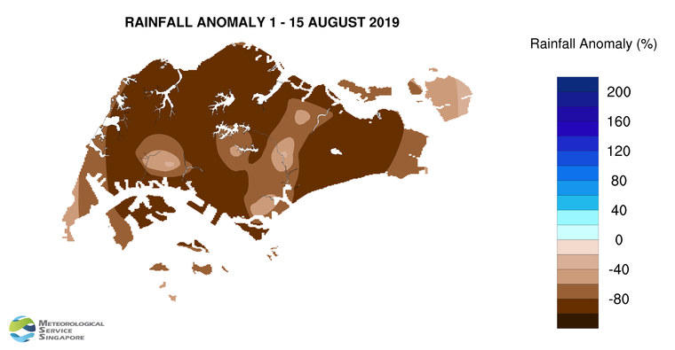
2           In the next fortnight, Singapore and the region can expect more wet days.  During the period, thundery showers are forecast over Singapore mostly in the late morning and early afternoon on six to eight days. In addition, the passage of Sumatra squalls could bring widespread thundery showers accompanied by gusty winds in the morning on one or two days. The rainfall for the first fortnight of September 2018 is likely to be near average for many parts of Singapore.

3          On most days in the fortnight, the daily temperature is forecast to range between 25°C and 33°C.  On a few days with little or no rainfall, warmer conditions with maximum temperatures of around 34°C can be expected .

4          For updates of the daily weather forecast, please visit our MSS website (https://www.weather.gov.sg), NEA website (www.nea.gov.sg), or download the myENV app, or the MSS’ Weather@SG app.

REVIEW (1 – 31 August 2018)

5          In August 2018, Southwest Monsoon conditions persisted over the region, and the low level winds were blowing predominantly from the southeast or southwest.

6          Compared to the first fortnight of August 2018, the second fortnight of the month was wetter due to a return of shower activities in the region.  During the month, the thundery showers fell mostly in the late morning and early afternoon, and the highest daily total rainfall was 90.3 mm recorded at Bukit Batok on 22 August 2018. On that day, large-scale wind convergence brought widespread moderate to heavy thundery showers between the morning and early afternoon.

7          The warmer conditions experienced in the first half of August 2018 gradually eased in the second half of the month with the return of shower activities. On most days in August 2018, the highest daily maximum temperature ranged between 31°C and 33°C.  Warmer temperatures were experienced between 11 and 15 August 2018 and on 27 August 2018, with the daily maximum temperature ranging between 33.9°C and 34.9°C. The daily minimum temperature in August 2018 ranged between 23°C and 27.1°C.

8         Well-below normal rainfall was recorded across the island in August 2018. The lowest rainfall of 43.7 mm (78% below average) was recorded at Choa Chu Kang West. Rainfall was highest at Changi where 121.4 mm (17% below average) was recorded.

FortnightRain_Anomaly_201809


CLIMATE STATION STATISTICS FOR SEPTEMBER (Climatological reference period: 1981 – 2010)

Mean daily maximum temperature 31.4 °C
Mean daily minimum temperature 24.8 °C
Mean monthly temperature 27.6 °C
Mean rainfall for the month 156.5 mm
Mean number of rain days 13
Highest monthly mean daily maximum temperature 32.2 °C (1997)
Lowest monthly mean daily minimum temperature 23.6 °C (1986)
Highest monthly rainfall 440.4 mm (1988)
Lowest monthly rainfall 23.7 mm (1994)

August 16, 2018

Gradual Easing of Dry and Warm Conditions in The Next Fortnight

Gradual easing of dry and warm conditions with increased showers forecast in 2nd fortnight of Aug’18. Expect 5-7 days of late morning and early afternoon thundery showers, and 2 or 3 days of morning Sumatra squalls.  A few warm days can still be expected.

Singapore, 16 August 2018 – The prevailing Southwest Monsoon conditions over Singapore and the region are forecast to persist for the rest of August 2018. In the next fortnight, the prevailing winds are forecast to blow from the southeast or southwest.

2          The dry and warm conditions experienced in recent days are expected to ease with a gradual increase in shower activities in the second half of August 2018. During the fortnight, short-duration thundery showers are forecast on five to seven days, with most of the rain falling between the late morning and early afternoon, and may on one or two days extend into the late afternoon. On two or three days, widespread moderate to heavy thundery showers accompanied by gusty winds due to Sumatra squalls can be expected in the morning. The rainfall for the August 2018 is likely to be below average for many parts of Singapore.

3          During the fortnight, the daily temperature is forecast to range between 25°C and 33°C on most days.  Warmer conditions with maximum temperatures of around 34°C and minimum temperatures of around 27°C can be expected on a few days with little or no rain.

4          For updates of the daily weather forecast, please visit our MSS website (https://www.weather.gov.sg), NEA website (www.nea.gov.sg), or download the myENV app, or the MSS’ Weather@SG app.

REVIEW (16 – 31 August 2018)

5          Southwest Monsoon conditions prevailed over Singapore and the surrounding region in the first fortnight of August 2018, and the low level winds during the period were predominantly from the southeast or southwest.

6          In the first fortnight of August 2018, most of the days were generally dry. Showers fell over the island on a few days during the period. The highest daily total rainfall of 66.7mm was recorded on 4 August 2018 at Changi, when heavy thundery showers fell over the northern and eastern parts of the island between the late afternoon and evening.

7         On most days in the first fortnight of August 2018, the highest daily maximum temperature was between 31°C and 33°C. In particular, between 11 and 15 August 2018, the weather was generally warm with the highest daily maximum temperature ranging between  34.0°C and 34.5°C. The warm conditions were due to dry weather coupled with strong solar heating. The daily minimum temperature in the first two weeks of August 2018 was mostly between 23.9°C and 27.9°C.

8         Well-below normal rainfall was recorded across the island in the first fortnight of August 2018. The lowest rainfall of 4 mm (96% below average) was recorded at Choa Chu Kang West. Rainfall was highest at Changi where 40.4 mm (45% below average) was recorded.

FortnightRain_Anomaly_201808a

CLIMATE STATION STATISTICS FOR AUGUST (Climatological reference period: 1981 – 2010)

Mean daily maximum temperature 31.4 °C
Mean daily minimum temperature 25.0 °C
Mean monthly temperature 27.9 °C
Mean rainfall for the month 148.9 mm
Mean number of rain days 14
Highest monthly mean daily maximum temperature 32.6 °C (1997)
Lowest monthly mean daily minimum temperature 23.9 °C (1989)
Highest monthly rainfall 327.3 mm (2008)
Lowest monthly rainfall 45.1 mm (1994)