New temperature and rainfall records for September 2019
End of dry weather with start of inter-monsoon period in coming fortnight. Expect more thundery showers (mostly afternoon), with high lightning activity. Few warm days (max temp around 35C). Sept 2019 rainfall and temperature records broken.
Fortnightly Weather Outlook for 1 – 15 October 2019
Singapore, 1 October 2019 – In the first fortnight of October 2019, the prevailing Southwest Monsoon conditions with low level winds blowing from the southeast or south are forecast to gradually weaken to become light and variable in direction. This change in conditions signal the cessation of the Southwest Monsoon season and the start of the inter-monsoon period.
2 Inter-monsoon conditions are forecast to prevail through November 2019, and is characterised by light winds and thunderstorms that are intense at times. The light winds, high moisture and strong day time heating of land areas are conducive for thunderstorm development. Lightning activity tends to be higher during the inter-monsoon period compared to other times of the year.
3 The monsoon rain band that has been hovering over the equatorial Southeast Asia region since late September 2019 is forecast to maintain its position over the region in the coming fortnight. This is expected to bring short-duration thundery showers over Singapore, mostly in the afternoon on eight to ten days. On a few of these days, the thundery showers can be expected in the late morning and extend into the afternoon. The rainfall for the first fortnight of October 2019 is forecast to be slightly above-normal over most parts of Singapore.
4 In the coming fortnight, more showers are forecast for the southern Southeast Asia region. The increase in rainfall is expected to bring a further improvement to the haze situation in the region, and the likelihood of transboundary haze affecting Singapore is thus low. However, Singapore could experience slightly hazy conditions on a few days, particularly in the early morning, due to an accumulation of particulate matter in the atmosphere under light wind conditions.
5 The first half of October 2019 is also forecast to be warm with the daily maximum temperature exceeding 35°C on a few days. On most days, the daily temperature is forecast to range between 25°C and 34°C. The night-time temperatures in the southern and eastern coastal areas of the island are expected to be warmer with daily minimum temperatures of 27°C or more on some days.
6 For updates of the daily weather and haze situation, please visit the MSS website (https://www.weather.gov.sg), NEA website (www.nea.gov.sg), or download the myENV app, MSS’ Weather@SG app, and the haze microsite (www.haze.gov.sg).
REVIEW (1 – 30 September 2019)
7 In September 2019, Southwest Monsoon conditions prevailed over the region with the low level winds blowing from the southeast or south, and on occasions from the southwest.
8 Singapore experienced drier and warmer-than-normal conditions in the first three weeks of September 2019. These conditions were due to suppressed raincloud formation arising from dry air blown to the southern Southeast Asia region from high pressure systems over Australia, coupled with the persisting cooler sea surface temperatures over the tropical Indian Ocean. There were however a few days during this period when showers fell over Singapore. In particular, the thundery showers on 4 September 2019 due to convergence of winds over Singapore and the surrounding vicinity brought showers over many parts of the island. The highest daily total rainfall of 93.3mm recorded over Jurong West that day was the highest recorded for September 2019.
9 In contrast, the last week of September 2019 was wet. The rainy weather was due to the moisture-laden easterly winds that were blown to the southern Southeast Asia region from the tropical Pacific Ocean. On 27 September 2019, an intense thunderstorm over the Tuas area generated a rotating column of winds, known as a landspout, over Gul Way. The landspout, which is the first reported occurrence in Singapore, lasted for several minutes and ripped off parts of a building’s roof.
10 Between 9 and 23 September 2019, Singapore experienced hazy conditions due to smoke haze from land and vegetation fires in Sumatra blown in by the prevailing winds. The 24-hour PSI during this period was between the Moderate and Unhealthy range, and remained in the Unhealthy range on some days (14-15 Sep, 17-19 Sep and 21 – 23 Sep 2019). The highest 24-hour PSI reading of 154, in the mid-section of the Unhealthy range, was recorded in southern Singapore between 2am and 4am on 19 September 2019. Showers in the last week of September 2019 helped to ease the hazy conditions over Singapore.
11 September 2019 was warm with the highest daily maximum temperature across the island reaching at least 34°C on more than 15 days in the month. The highest daily maximum temperature of 35.0°C was recorded at Tai Seng on 21 September 2019.
12 Based on the climate station records, September 2019 is the warmest and the driest September in Singapore since temperature and rainfall records began in 1929 and 1869 respectively. The monthly mean temperature for September 2019 was 29.0oC, 0.2oC warmer than the previous record set in September 1997. September 2019 also saw a new record for the highest September mean daily maximum of 33.0oC, far exceeding the previous record of 32.2oC (in September 1997) by 0.8oC. Another record was set for the highest September mean daily minimum temperature of 26.6oC, 0.1oC higher than the previous record in September 2015. The monthly total rainfall last month was 22.8 mm, breaking the previous September record low rainfall of 23.7 mm in September 1994.
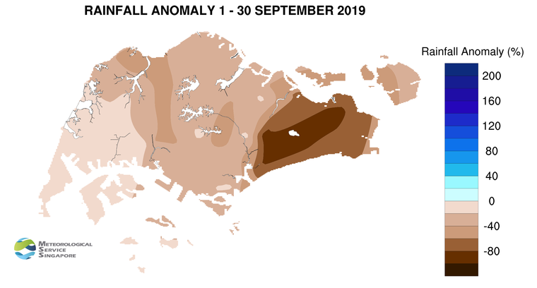
13 Significantly below-average rainfall was recorded across Singapore in September 2019. The lowest anomaly of 85% or more below-average was recorded at a few stations in the eastern part of the island. The total rainfall recorded at rainfall stations across the island with long-term records for September 2019 was 44% below September’s climatological normal. September 2019 is thus the third consecutive month, following July and August 2019, with more than 40% below-normal monthly rainfall giving rise to a rainfall deficit situation[1] (the total rainfall for July 2019 and August 2019 was 51% and 81% below normal respectively). The last occurrence of a rainfall deficit situation in Singapore was in 2014 from January to March, where the average rainfall total for each month across Singapore was 67%, 89% and 50% below the month’s normal.
[1] A rainfall deficit situation refers to a period of at least 3 consecutive months with monthly rainfall more than 40% below the climatological rainfall, averaged over the rainfall stations with long term records across the island.
CLIMATE STATION STATISTICS
Long-term Statistics for October
(Climatological reference period: 1981 – 2010)
| Average daily maximum temperature |
31.7 °C |
| Average daily minimum temperature |
24.7 °C |
| Average monthly temperature |
27.6 °C |
| Average rainfall |
154.6 mm |
| Average number of rain days |
15 |
Historical Extremes for October
(Rainfall since 1869 and temperature since 1929)
| Highest monthly mean daily maximum temperature: |
33.0 °C (2002) |
| Lowest monthly mean daily minimum temperature: |
22.8 °C (1964) |
| Highest monthly rainfall ever recorded: |
497.1 mm (1942) |
| Lowest monthly rainfall ever recorded: |
10.8 mm (2002) |