Wet and humid weather to persist in 1st half of Sep’20. Late morning and afternoon thundery showers on most days; widespread thundery showers with gusty winds on 1 or 2 mornings. Daily temp between 24°C and 33°C (most days), with highs ard 34°C (few days), and some warm nights.
Fortnightly Weather Outlook for 1 – 15 September 2020
Singapore, 1 September 2020 – The weather in the first half of September 2020 is expected to be similar to that in the last fortnight of August 2020, with thundery showers and humid conditions forecast on most days. In the next fortnight, the daily maximum temperature is forecast to range between 32°C and 33°, and with daily highs of around 34°C on a few days. Toward the second week of September 2020, warm weather can be expected on some nights.
2 The prevailing Southwest Monsoon conditions in the region are forecast to persist in the first fortnight of September 2020. During the period, the low-level winds are expected to blow from the southeast or southwest, and may on brief occasions, blow from the west.
3 In the first fortnight of the month, the monsoon rain band is expected to lie close to the equatorial Southeast Asia region. For Singapore, short-duration moderate to heavy thundery showers are forecast over parts of the island between the late morning and afternoon on most days. In addition, widespread thundery showers with gusty winds due to the passage of Sumatra squalls are expected on one or two mornings. The total rainfall in the first fortnight of September 2020 is forecast to be above-average over most parts of the island.
4 Despite showers falling over the island on most days in the fortnight, it can still be warm on a few days where the daily maximum temperature could reach around 34°C. On most days, the daily temperature is forecast to range between 25°C and 33°C. Toward the second week of the month, the weather on some nights can be warm and humid with night-time temperatures around 28°C. This occurs when the prevailing southeast winds strengthen and blow warm, humid air from the sea over the land.
5 For updates of the daily weather and haze situation, please visit the MSS website (https://www.weather.gov.sg), NEA website (www.nea.gov.sg), or download the myENV app, MSS’ Weather@SG app, and the haze microsite (www.haze.gov.sg).
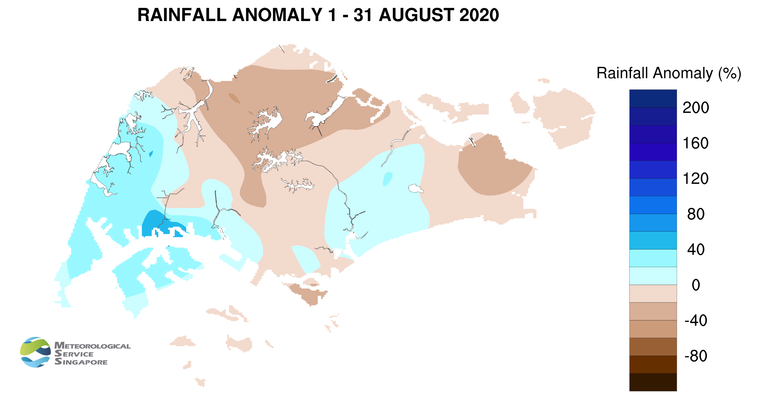
REVIEW (1 – 31 August 2020)
6 In August 2020, Southwest Monsoon conditions prevailed over the region with the low-level winds blowing from the southeast or southwest. Under the influence of a few tropical storms over the South China Sea and the northwestern Pacific Ocean, the prevailing winds strengthened and blew from the west on some days.
7 With the monsoon rain band situated over the equatorial region in the latter half of August 2020, more rain fell over Singapore in the second fortnight compared to the first fortnight of the month. Moderate to heavy thundery showers due to strong solar heating of land areas fell over the island in the late morning and afternoon on most days and extended into the evening on a few days. There were a few mornings where the passage of Sumatra squalls brought widespread thundery showers with gusty winds to Singapore. On 13 August 2020, moderate to heavy thundery showers fell over the island in the morning. The daily total rainfall of 115.6mm recorded at Bedok South that day was the highest total rainfall recorded for the month.
8 In August 2020, there were several dry and warm days, mostly in the first half of the month, where the daily maximum temperature was above 34°C. The highest daily maximum temperature of 35.4°C was recorded at Admiralty on 9 August 2020. There were also several nights that were warm with night-time temperatures above 28°C, particularly over the southern, eastern and western coastal areas of the island. More rain fell over the island in the second half of August 2020. During this period, it was relatively cooler compared to the first half of the month, and the daily maximum temperature was below 33°C on nine days. At the Changi climate station, the mean monthly temperature for August 2020 was 28.3°C, 0.4°C higher than the month’s long-term average.
9 About one-third of the island recorded above-normal rainfall in August 2020. The rainfall recorded over Jurong area was 54% above-average, while that recorded at Admiralty was 42% below average.
CLIMATE STATION STATISTICS
Long-term Statistics for September
(Climatological reference period: 1981 – 2010)
| Average daily maximum temperature |
31.4°C |
| Average daily minimum temperature |
24.8 °C |
| Average monthly temperature |
27.6 °C |
| Average rainfall |
156.5 mm |
| Average number of rain days |
13 |
Historical Extremes for September
(Rainfall since 1869 and temperature since 1929)
| Highest monthly mean daily maximum temperature: |
32.2 °C (1997) |
| Lowest monthly mean daily minimum temperature: |
22.4 °C (1930) |
| Highest monthly rainfall ever recorded: |
440.4 mm (1988) |
| Lowest monthly rainfall ever recorded: |
23.7 mm (1994) |