Singapore, 1 September 2021 – The weather in the first fortnight of September 2021 is expected to be less wet with a few warm days compared to the second fortnight of August 2021. In the coming fortnight, the prevailing Southwest Monsoon conditions are forecast to persist over Singapore and the surrounding region, and the low-level winds are expected to blow from the southeast or southwest.
2 In the first half of September 2021, the monsoon rain band is expected to lie over the equatorial Southeast Asia region. Short-duration thundery showers are forecast between the morning and early afternoon over some parts of Singapore on most days. On a few days, Sumatra squalls from the Strait of Malacca may bring widespread thundery showers with occasional gusty winds over Singapore between the early and pre-dawn hours, as they move eastward toward the South China Sea. On one or two days, widespread moderate to heavy thundery showers can be expected when prevailing winds in the region converge over Singapore and the surrounding region. The total rainfall for first half of September 2021 is forecast to be above average over most parts of the island.
3 During the fortnight, the daily temperature on most days is expected to range between 24°C and 33°C. On one or two rainy days, the daily minimum temperature may dip to around 22°C. In the latter half of the fortnight, the daily maximum temperature could reach a high around 34°C on a few days. On some nights, warm and humid conditions can be expected when prevailing winds from the southeast or south blow warm and humid air from the sea. The minimum night-time temperatures may reach around 28°C, particularly over the south-eastern parts of the island.
4 For updates of the daily weather forecast, please visit our MSS website (https://www.weather.gov.sg), NEA website (www.nea.gov.sg), or download the myENV app.
REVIEW (1 – 31 August 2021)
5 In August 2021, Southwest Monsoon conditions prevailed over the region, and the low-level winds blew from the southeast or southwest on most days, and from the east on a few days.
6 August 2021 was a relatively wet month with well-above average rainfall recorded across the island. The wet weather can be attributed to the influence of the negative phase of Indian Ocean Dipole (IOD) [1] , the convergence of surrounding winds, as well as the passage of a wet phase of Madden-Julian Oscillation (MJO) [2] over the equatorial region.
7 In August 2021, there were several days where the rain was heavy over some parts of the island. On the morning of 20 August 2021, convergence of prevailing winds from the south and west-northwest brought widespread moderate to heavy thundery showers over the island. The rain was heaviest over the central, northern, and eastern parts of Singapore, and more than 100mm of rain fell over several areas including Hougang, Choa Chu Kang, Pasir Ris, and Ang Mo Kio that morning. On 24 August 2021, a few spells of widespread moderate to heavy thundery showers fell over the island in the pre-dawn hours and morning, followed by light to moderate rain in the afternoon. The highest daily total rainfall recorded that day was 247.2mm at Mandai. This is the highest daily total rainfall for August 2021 and has surpassed the record highest daily total rainfall of 181.8mm (at Changi on 22 August 1983) for August.
8 Based on the rainfall averaged over long-term stations island-wide, August 2021 is the wettest August since 1980, with a monthly total rainfall of 426.2mm. This has surpassed the record highest August rainfall of 346.6mm set in August 1996. At the Changi climate station, the total rainfall for August 2021 was 293.6mm, which is the second highest August rainfall after August 2008 (at 327.3mm) since 1980. The Changi climate station also recorded a total of 24 rain days in August 2021, well above the long-term average of 14 days for August.
9 In August 2021, the daily maximum temperature was below 34.0°C on most days due to the rainy weather. The lowest daily minimum temperature was 21.3°C recorded at Newton on 24 August 2021. There were a few warm days mainly in the first half of August 2021, and the highest daily maximum temperature recorded in August 2021 was 34.9°C at Marina Barrage on 3 August 2021.
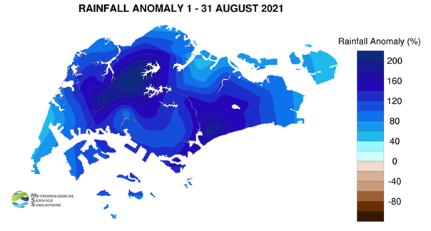
10 Rainfall in August 2021 was well-above average across the island, with most of the rain falling in the northern and western parts of Singapore. The highest anomaly of 240% above average was recorded at Bukit Panjang.
[1] The IOD refers to the sustained change to the different between sea surface temperatures (SSTs) of the tropical western and eastern Indian Ocean. The IOD varies between three phases – positive, negative and neutral. A negative phase occurs when warmer SSTs develop in the eastern Indian Ocean, resulting in above average rainfall over Singapore and the surrounding region.
[2] The MJO is characterised by a large-scale “pulse” of rain clouds that move eastward around the equator with a typical cycle of 30-60 days.
CLIMATE STATION STATISTICS
Long-term Statistics for September
(Climatological reference period: 1991 – 2020)
|
Average daily maximum temperature: |
31.6 °C |
| Average daily minimum temperature: |
25.2 °C |
| Average monthly temperature: |
28.0 °C |
| Average rainfall: |
124.9 mm |
| Average number of rain days: |
13 |
Historical Extremes for September
(Rainfall since 1869 and temperature since 1929)
|
Highest monthly mean daily maximum temperature: |
33.0 °C (2019) |
| Lowest monthly mean daily minimum temperature: |
22.4 °C (1930) |
| Average monthly temperature: |
28.0 °C |
| Highest monthly rainfall ever recorded: |
440.4 mm (1988) |
| Lowest monthly rainfall ever recorded: |
22.8 mm (2019) |