Southeast Asia Regional Centre
WMO Vegetation Fire and Smoke Pollution
Warning and Advisory System (VFSP-WAS)
WMO Vegetation Fire and Smoke Pollution Warning and Advisory System (VFSP-WAS)
Introduction
Vegetation fires release large amounts of particulate matter (PM) and toxic gases including carbon monoxide, nitrogen oxides, and non-methane organic compounds into the atmosphere. Studies have demonstrated that smoke PM from vegetation fires is associated with respiratory and cardiovascular effects and that exposure to fire emissions represents the highest risk to vulnerable subsets of the population i.e. people with existing respiratory or cardiovascular illnesses, infants and the elderly.
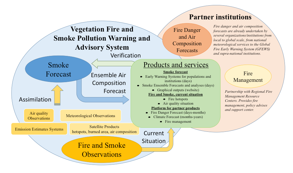
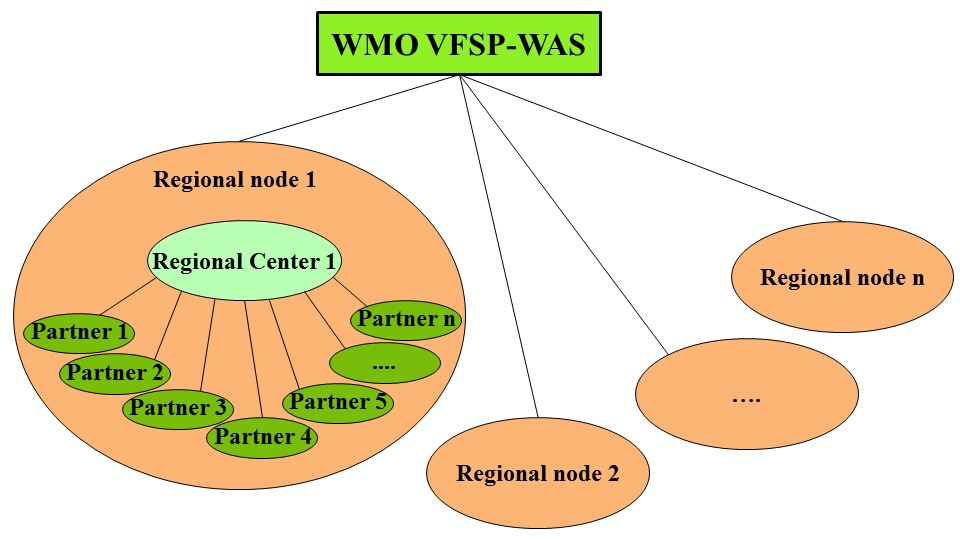
Recognising the need for international coordination of a diverse community dealing with the societal impacts of fires and smoke pollution, the World Meteorological Organization (WMO) has taken the lead with international partners to develop and implement the VFSP-WAS. The VFSP-WAS is an international network of research, national operational centres and users organised through regional nodes assisted by regional centres.
For more information, refer to:
Mission
The VFSP-WAS aims to enhance the ability of countries to deliver timely and quality vegetation fire and smoke pollution forecasts, observations, information and knowledge to users through an international partnership of research and operational communities.
Overview of the VFSP-WAS
Objectives
1. To provide data and information that can be used to capacitate relevant actors regionally, nationally and locally to reach informed decisions as they work to prevent destructive fires.
2. To provide data and information that is relevant and helpful for specific agencies in individual countries that are tasked with dealing with emergencies in the context of public health, fire management and law enforcement.
3. To provide data and information that can be used by the Regional Fire Management Resource Centres in the effort to advise and capacitate relevant actors regionally, nationally and locally to develop fire management policies and implementation strategies and reach informed decisions in fire management.
4. To facilitate the use of fire and smoke prediction at the regional level, to protect health, economic activities and the environment.
5. To facilitate the use of fire and smoke observations by users regionally, nationally and locally.
6. To provide centralised expertise to regional WMO Members, advice and training to support the establishment and improvement of fire and smoke observations and predictions.
Structure of the VFSP-WAS
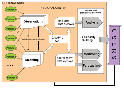
Regional Nodes and Centres
At the regional level, VFSP-WAS is organised as a federation of regional partners and realised through regional activity Nodes and Regional Vegetation Fire and Smoke Pollution Warning and Advisory Centres (RVFSP-WAC). The organisation of regional nodes research, development and forecasting activities within each node is defined and led by a VFSP-WAS Regional Steering Group (RSG) and coordinated by the Regional Centre.
Schematic structure of a RVFSP-WAC