Global Fire Weather Database
The Global Fire WEather Database (GFWED) integrates different weather factors influencing the likelihood of a vegetation fire starting and spreading. It is based on the Fire Weather Index (FWI) System, the most widely used fire weather system in the world. The FWI System was developed in Canada, and is composed of three moisture codes and three fire behavior indices. The moisture codes capture the moisture content of three generalized fuel classes and the behavior indices reflect the spread rate, fuel consumption and intensity of a fire if it were to start. Details on the development and testing of GFWED can be found in Field et al. (2015), applications of the FWI System can be found in Taylor and Alexander (2006), and technical descriptions are provided by van Wagner (1987) and Dowdy et al. (2009).
FWI System calculations require measurements of 12:00 local time temperature at 2m, relative humidity at 2m, and wind speed at 10m, daily snow-depth, and precipitation totaled over the previous 24 hours.
GFWED is comprised of eight different sets of FWI calculations, all using temperature, relative humidity, wind speed and snow depth estimates from the NASA Modern Era Retrospective Analysis for Research and Applications version 2 (MERRA-2) (Rienecker et al., 2011). The precipitation estimates for the products below are based on GPM IMERG Early, NRT version.
- Fine Fuel Moisture Code
- Duff Moisture Code
- Drought Code
- Initial Spread Index
- Build Up Index
- Fire Weather Index
| Class Ignition Potential |
Interpretation |
| Low |
Low probability of fire starts. |
| Medium |
Moderate probability of fire starts in areas of local dryness. |
| High |
Grass fuels becoming easily ignitable. Higher probability of fire starts. |
| Extreme |
Grass fuels highly flammable. Very high probability of fire starts. |
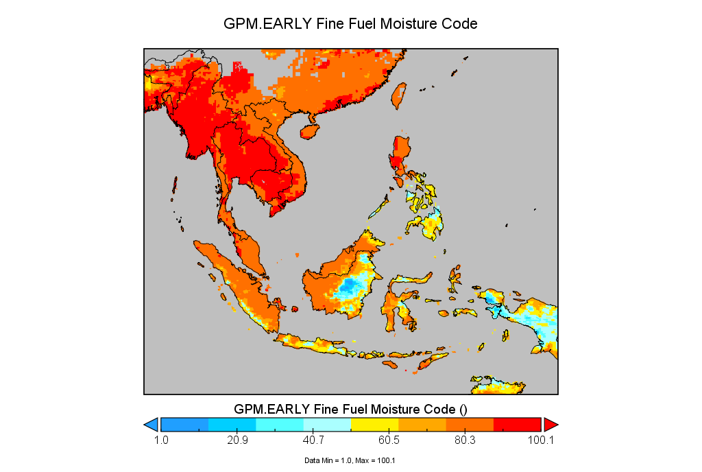
The FFMC values shown on the map are numerical ratings of the moisture content of litter and other cured fine fuels. The FFMC values are used to indicate the flammability of fine fuels and the relative ease of ignition.
| Class Ignition Potential |
Interpretation |
| Low |
Top layers of organic soil are wet. |
| Medium |
Top layers of organic soil are moist. |
| High |
Top layers of organic soil becoming dry. |
| Extreme |
Top layers of organic soil are dry. |
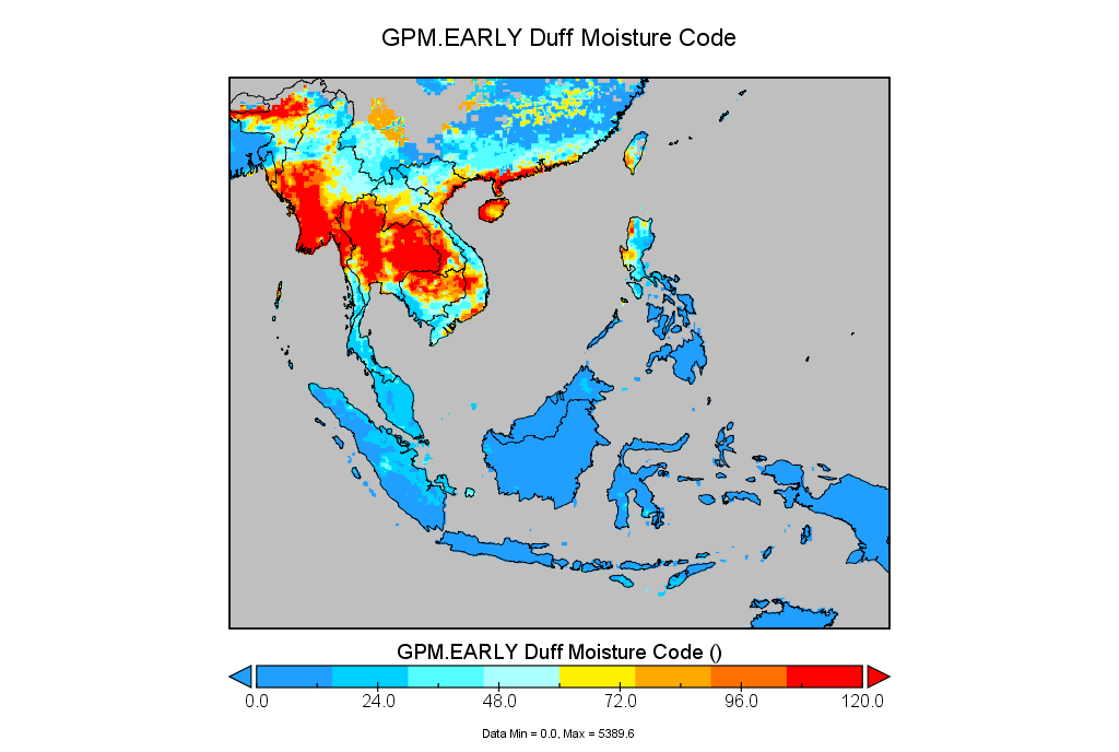
The DMC values shown on the map are numerical ratings of the average moisture content of loosely compacted surface organic layers (duff). The DMC indicates the level of fuel consumption in surface organic layer and medium-sized woody material.
| Class Ignition Potential |
Interpretation |
| Low |
Typical wet-season conditions and severe haze periods are unlikely. More than 30 dry days until DC reaches threshold at which point severe haze is highly likely. |
| Medium |
Normal mid dry-season conditions. Between 15 and 30 dry days until DC reaches threshold. Burning should be regulated and monitored as usual. |
| High |
Normal dry season peak conditions. Between 5 and 15 dry days until DC reaches threshold. All burning in peatlands should be restricted. Weather forecast and seasonal rainfall assessments should be monitored closely for signs of an extended dry season. |
| Extreme |
Approaching disaster-level drought conditions. Less than 5 dry days until DC reaches threshold, at which point severe haze is highly likely. Complete burning restriction should be enforced. |
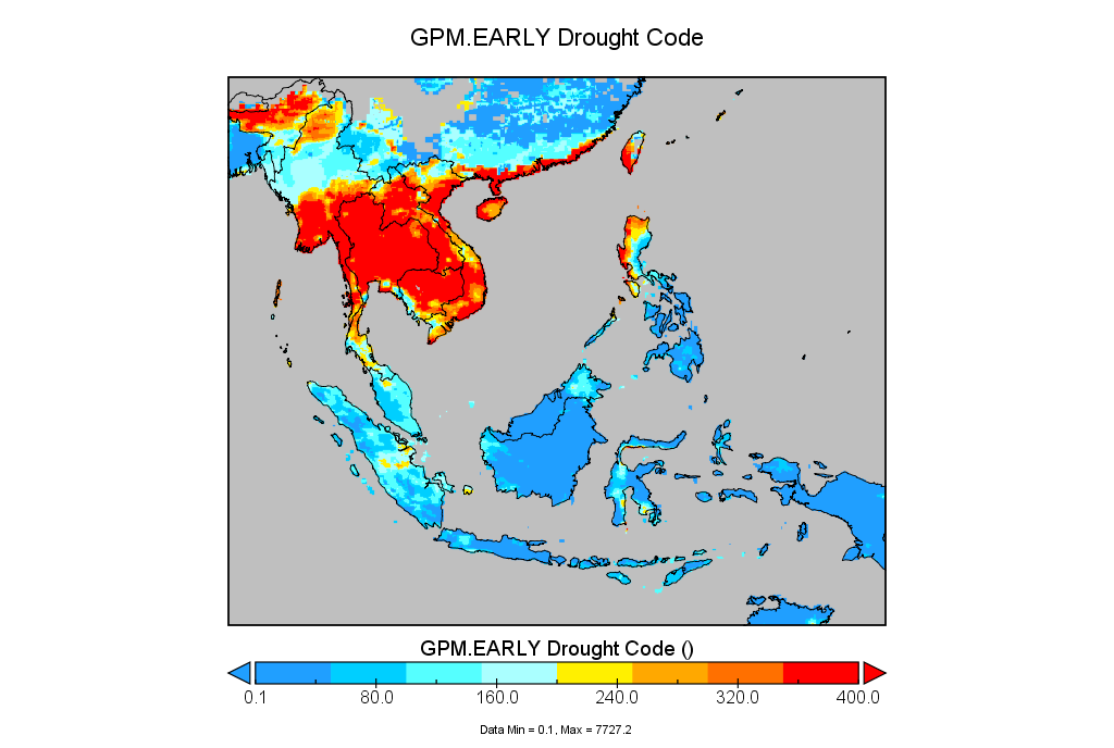
The DC values shown on the map refer to how much moisture content is contained within the deep layer of compact organic matter. The higher the DC values, the higher the potential for fire to smoulder in peat, which indicates greater difficulty in extinguishing the fires.
| Class Ignition Potential |
Interpretation |
| Low |
Fires will be self-extinguishing. |
| Medium |
Fire can be easily suppressed with hand tools. |
| High |
Most fire can be successfully controlled using power pumps and hose. |
| Extreme |
Some fires will be difficult to control. |
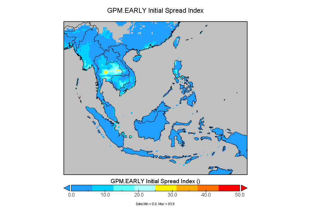
The ISI is a measure of the head fire indicator and rate of fire spread. The higher ISI index indicates higher difficulty of control in grassland. It is a combination of the effects of the wind speed and Fine Fuel Moisture Code.
| Class Ignition Potential |
Interpretation |
| Low |
Medium and heavy fuels are generally not combustible. |
| Medium |
Very low amount of medium and heavy fuels available for combustion. |
| High |
Low to moderate amount of medium and heavy fuels available for combustion. |
| Extreme |
Moderate to high amount of medium and heavy fuels available for combustion. |
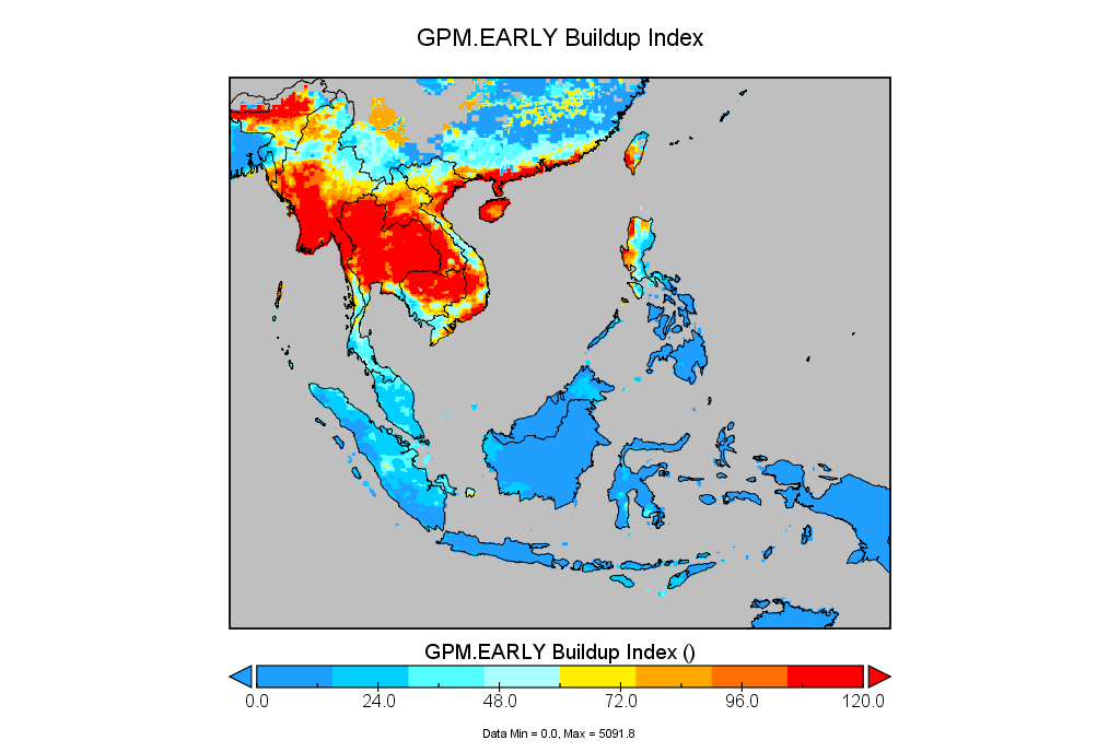
The BUI values shown on the map indicate amount of fuel available for combustion. It combines Duff Moisture Code and Drought Code which represent medium and heavy dead fuels respectively.
| Class Ignition Potential |
Interpretation |
| Low |
Low fire intensity. Fire will spread slowly or be self-extinguishing. Grassland fires can be successfully controlled using hand tools. |
| Medium |
Moderate fire intensity in grass. Hand tools will be effective along the fire's flanks, but water under pressure (pumps, hose) may be required to suppress the head fire in grasslands. |
| High |
High fire intensity in grass. Direct attack at the fire's head will require water under pressure, and mechanized equipment may be required to build control lines. (e.g: bulldozer) |
| Extreme |
Very high fire intensity in grass. Fire control will require construction of control lines by mechanized equipment and water under pressure. Indirect attack by back-burning between control lines and the fire may be required. |
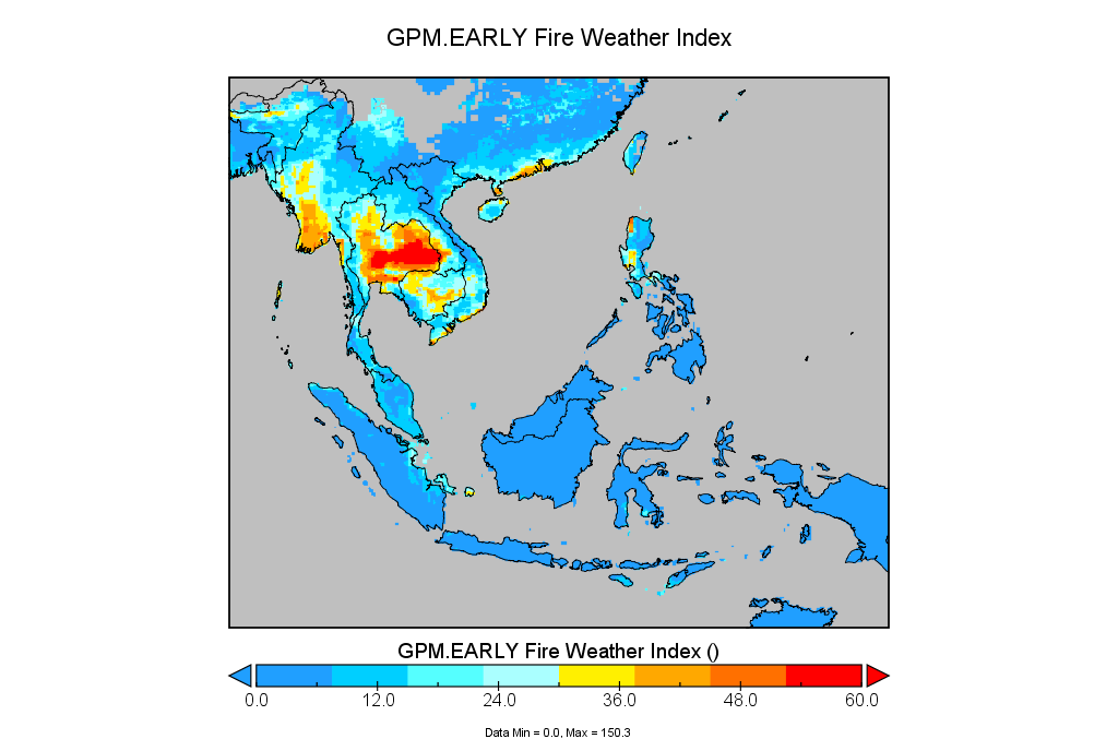
The FWI values refer to the fire intensity and general fire danger across the landscape, after taking into account of Initial Spread Index and Build Up Index. This index is related to the difficulty of fire control based on the head fire intensity and fire-fighting capability.
Images courtesy of NASA Goddard Institute for Space Studies.